

Karahunj – Calculation of the angle of inclination of the earth’s axis 7500 years ago
January 22, 2018 – Antiquities, History:
 Did Karahunj astronomers know the angle of Earth Axis Incline (anglee or Ecliptic Inclination)? Yes, because (see Fig. 26) they could measure the height (elevation angle hI) of Sun in its summer culmination (in midday at Summer solstice, the longest day, June 22) and its height (angle h2) in Winter culmination (in midday at Winter solstice, the shortest day, December 22)*.
Then they could find the Sun declination (a) in culmination days (angle ac) as Of course, they had seen that during the year the Sun elevation (h) changes in limits hI> h > h2 and declination – in limits – ac< a< + ac • Reiterating these measurements many years and becoming sure that &: is almost not changed (and even did not depend on latitude (cp) of place, see below) they had to understand that the Sun direction in Solstices is inclined to the Earth’s Equator Plane (or Sky Equator, a=0) for the angle -e=-§-c

Earth Axis is inclined to the normal to Ecliptic Plane for the angle e=&:. And this is the reason why we have on Earth Summer and Winter (Solstices), Spring and Autumn (Equinoxes). Using Fig. 27 it is easy to find relation between e, cp and Azimuth of Sunrise (Sunset) point As on horizon. It is the following:


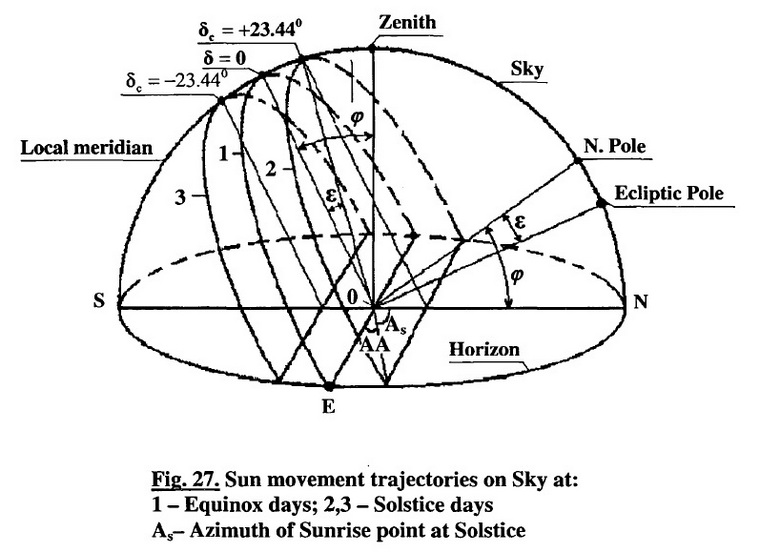
Did Karahunj astronomers know about Earth rotation around its own Axis? Yes, because they knew that Earth has the Axis of rotation and even knew the angle (e) of its Incline and its Precession (see Item 1.22). According to G. Hancock the Earth Axis Incline changes in limits from 22.1° to 24.5° with period of 41 thousand years [24]. According to Astronomical Yearbooks the Ecliptic Inclination now is equal e =23.44° and slowly decreases with speed 0.00013° (0.47″) per year”.
We can use also the value for speed A£ =0.013° (0.78′) per 100 year, because we are now in linear part of the sine-kind law of Inclination changing (Fig. 28). Thus the Azimuth of Sunrise point at Solstice (As) also decreases and angle (90 – As) as well as Azimuth Shift (Ms) increases (see Fig. 26). Using equation (3) we can calculate, that when e = 23.44° and latitude q> = 39.5° (Karahunj), As = 58.97° and if Ae = 0.013° then Ms= 0.018° or 1.1′ during 100 year.
Having accuracy of observations (with pipes) 30″ =0.5′ old astronomers theoretically could mark the shift Ms= 1.1′ after 50 years, but practically it was impossible, because the pipes had not so high time-stability. But using Holes even without pipe (and having the accuracy of 3.5′) they had to mark Ms after about 300 years (the stone instruments have very high stability).
After 1000 year the shift could be Ms = 0.18° or 11′ which is 3 times more than the accuracy without pipes. Finding this, they would make other new stone instruments for Sunrise (Sunset) in Solstice days directed to the new point, Le, with some azimuthal shift, to have Sunrise point again in centre of holes.
In fact in Karahunj there are indeed a number of stones approximately directed to the present Sunrise (Sunset) point at Solstices having some shifts between holes directions (which we measured). So we know the shifts between present Sunrise point and old points.
These give a possibility to calculate the age of stones and of Observatory as a whole. Let us return to Fig. 28 and explain it a little. The variation of Earth Axis Incline is in limits ± 1.2° (e =23.3° ± 1.2°). It practically does not change a heat value coming from Sun to the tropic, subtropical and moderate zones of the Earth.
But this small change of e is very sensible for regions, which are close to arctic zones. So Axis Incline change law (sine-kind) acts an important role near arctic, because the Sun rays are coming with too sharp angles and this conduces to forming a large glacial covering in subarctic zones, with period of 41000 years.
The last glacial period started about 32000 years ago and finished 12000 years ago (see Fig. 28). In the last 2000 years of this period ice melted very intensively and 12000 years ago the Great Deluge took place. In the result the level of ocean rose up to 100 m.Tt was too dangerous for Mesopotamia and other low altitude places but not for Armenian Highland with average altitude 1700 m (Mount Ararat 5160 m).
There were clouds, lightning, rains, rough rivers, etc, but nothing dangerous for life of people, animals, and flora. Armenian Highland was the real Noah’s Ark and the civilization here continued to develop. Our Present time is on linear part of Axis decline changing law, so the beginning of the next Glacial period will be after 8500 years and next Great Deluge after 29000 years (Fig. 28).

* Below (Fig. 35-37, Item 1.28) the Karahunj Three-Stone Instrument used for measurements of Sun elevation at equinox days (~ = 0, h =90 – cp) and also for measurements of latitude (angle cp) of place is shown.
• It is interesting to notify here that Armenian author of XVll century gives for this angle the value 23.5° [19]. This was a very good result because the actual value has been about 23.445°.
An extract from the book “Armenians and Ancient Armenia” by Paris Heoruni.
To date, The Prehistoric Wonder in Armenia Karahunj is included in the Top Ancient Sites for Stargazing in National Geographic
allinnet.info/antiquities/karahunj-calculation-of-the-angle-of-inclination-of-the-earths-axis/?